 |
| Home | Geography | History | Biology | Recreation | News | Resources |
| Timeline | Narrative | Events | Places | People |
The Story of Meetinghouse Hill
The 33-acre Meetinghouse Hill field is across Route 30 from the Vernon Center Middle School extending to Cemetery Road. It's one of the most historic places in Vernon. This its story. Click on images for full size. For those who would like more detail and documentation the story is expanded here. In The BeginningVernon lies at the edge of the Eastern Highlands as it rises above the Connecticut River Valley. The Highlands were formed about 300 million years ago when tectonic plates collided and pushed up a Himalayan sized mountain range extending along the east coast of North America. About 225 million years ago the plates began moving apart creating a rift valley - the Hartford Basin. The mountains eroded over millions of years leaving our relatively gentle hills. Glaciers came and went smoothing off mountain tops and scouring river valleys. The last glacier receded about 16,000 ago leaving Vernon with glacial till, drumlins, kettles and an abundance of glacial boulders. As the last glacier withdrew life returned to the area. Vegetation took hold and as it did animals returned. The flora and fauna were much like we find here today. The Podunk Indians
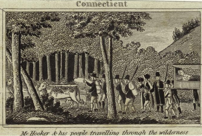
About the time the last glacier left Connecticut the First People were making their way across the land bridge from Asia to North America. They moved south and began to fan out across the continent, moving ever eastward until they reached the Atlantic. They arrived in New England 5,000 to 10,000 years ago. By the time Europeans arrived the natives had a long history, a settled way of life and pressure from neighbors. Vernon was Podunk territory, crisscrossed by trails used for travel, trading and hunting. The Podunks had their primary villages along the Connecticut River where they spent summers and had extensive corn fields. In the winter they moved inland to places like Vernon to hunt and fish. Vernon was heavily wooded for game and the cold streams of the Tankerhoosen and Hockanum Rivers provided good fishing. Shenipsit Lake was a favorite winter campground shared with neighboring tribes. Early maps show a major trail crossing Vernon from southeast to northwest. It crossed the Tankerhoosen at Talcottville and then followed the ridge line separating the Hockanum and Tankerhoosen River watersheds to Tolland, and on to the village at Stafford Springs; generally the path of today's Route 30. This was a good route as the land rises gently from the Hockanum River to the hills of Tolland so the ridge line was dry and firm. From the top of Meetinghouse Hill travelers had a view back over the Connecticut River Valley, perhaps a reason for choosing this path. What might the Indians have named this spot? This path may have been used for thousands of years to travel from northeast Connecticut and Massachusetts to the Connecticut River. This same route was followed by our first settlers. Early SettlersRev. Thomas Hooker and his congregation with families and 100 cattle in 1636 journeyed through Willington, Tolland and Vernon on their way to Hartford according to Old Connecticut Path researcher Jason Newton. With wagons and cattle they followed well worn Indian paths. In Vernon they could descend to the Tankerhoosen River to water and graze their cattle. From Meetinghouse Hill they may have caught the first glimpse of their new home in Hartford.
With Hooker and the early settlers of Windsor and Wethersfield came many of the families whose grandsons would settle Vernon - the Talcott, Skinner, Bissell, Alford, and Thrall families. As an example of how Vernon was settled John Talcott came to Hartford with Hooker in 1636. The settlers were far more than farmers as they had to build, govern and protect their settlements. The new settlers purchased large properties from the Indians. In England land passed to the oldest son and younger sons joined the church or had to find another path in the world. In Connecticut the pioneers planned for all their family to have good properties. Thus John Talcott's son Samuel was settled in Wethersfield, Samuel's son Benjamin received property in Glastonbury, and his son Benjamin built his farm on family land in Bolton. From this Benjamin descends the Talcott's who settled in North Bolton as farmers, mill owners and bankers. Other early settlers of Vernon followed a similar path. Bolton was recognized by the General Assembly as a town in 1720 and proceeded to divide its land among 50 proprietors. Most chose land in the southern part of town where it was more attractive for farming and closer to their meetinghouse. Remember church attendance was a duty, so each Sunday families set off, mostly on foot, to spend the day at worship. As with their forefathers sons were given land to begin their farms, now in North Bolton, with some of the best land along the old east-west Indian trail separating the Hockanum and Tankerhoosen River valleys. The old trail gradually became Hartford Turnpike; now used for trade and journeying to Hartford and eastward to Boston. Over time families grew and new settlers moved into the area. When there were enough families they petitioned for a separate parish. Thus in 1749 eighteen families from North Bolton petitioned the General Assembly for the privilege of a Winter parish, which was granted. Gatherings were then held during the cold months in private homes. In 1760, when the population had grown to about sixty families, the Ecclesiastical Society of North Bolton was formed with a territory similar to present day Vernon. It was known as the Second Church of Christ in Bolton until Vernon was incorporated in October 1808. The parishioners immediately began to plan their meetinghouse. Our First Meetinghouse
Meeting houses were located in the center of the community, near a crossroad and preferably on a hill. The site chosen, later called Old Meetinghouse Hill, was not at the corner of Center Road and Hartford Turnpike, but a half mile to the east near the corner of Bamforth Road. Recall that the Old Burial Ground of North Bolton was established on Bamforth Road in 1751, ten years before the church was planned. The cemetery would have been near the center of the community at the time. The site for the church was at the top of the hill overlooking the Tankerhoosen and Connecticut River Valleys. From the hill parishioners could see the steeple of Thomas Hooker's Church in Hartford. A wooded half acre site was given by the heirs of Samuel Bartlett. Familiar names on the building committee were Allis, Dart, Strong, Thrall, King and Olcott. The meeting house was raised on May 6, 1762 and the first worship was held there on June 20. Building the church was probably much like an old fashioned barn raising where the community came together for a weekend with whole families participating. The meeting house fronted the highway on the South with horse sheds and a school house located nearby. The church had 35 members who transferred from Bolton. When first used it was little more than a shelter for the congregation. Slow progress was made in fitting the building owing to the slender means of the people. It remained without pews until 1770 and was not plastered until 1774.
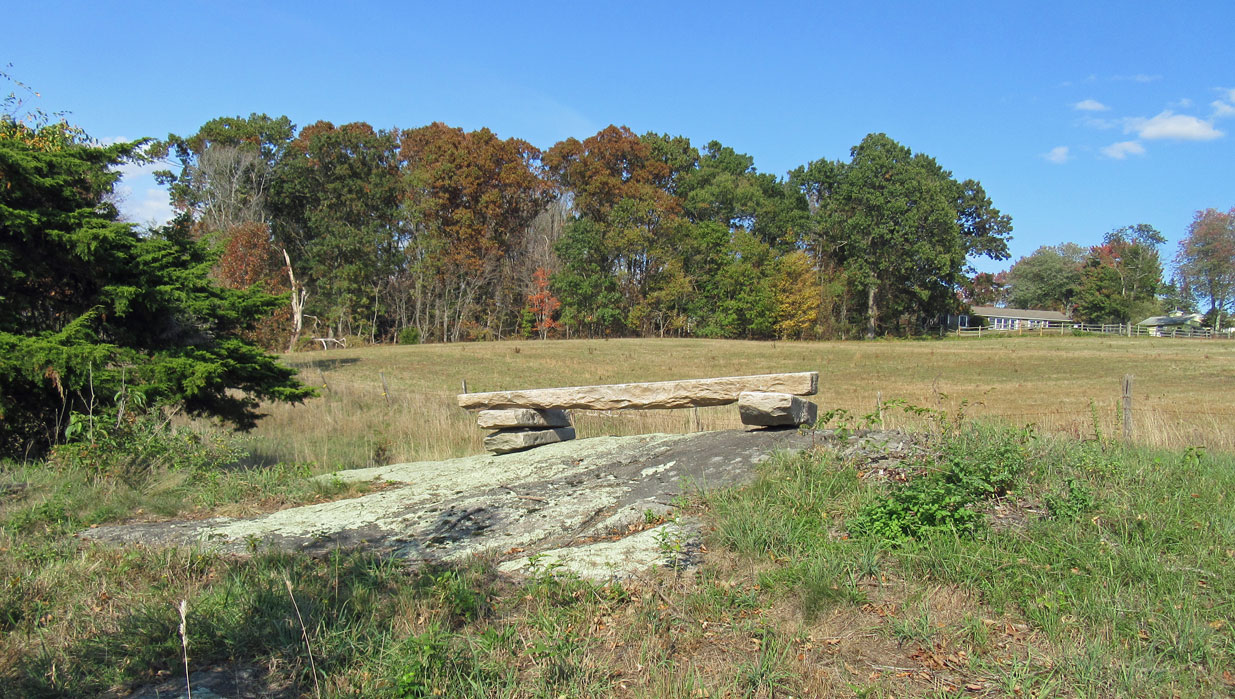
On March 29, 1762 they voted to call Rev. Ebenezer Kellogg, a 25 year-old Yale graduate, as their first minister. He read his lengthy sermons, which were serious discourses carefully setting forth the doctrines and duties of religion. The theology of the church was stern in theory and strict in practice. After serving 55 years he died in 1817 at the age of 80 and was buried in the Old Burying Ground on Bamforth Road. Many of his descendants remained in the area as successful farmers, landowners and mill operators. The meeting house was far more than a place of worship. Other than schoolhouses, which were established early, this was the only public building in town. The church was the center of community life in rural New England. Government meetings and other important gatherings took place there. Each Sunday farmers would travel from their homesteads to the Meetinghouse to worship, meet their neighbors and ?tell the news.' To reach the meeting house from the west worshipers climbed the field at Meetinghouse Hill. On the path a fieldstone bridge was built to cross a small brook and marshy area. Before church on Sundays the young women from the surrounding farms would bring their shoes and stockings, and sometimes their dresses to a nearby house where they would change into their good clothes before they started up the hill, changing again on their return from the afternoon service.
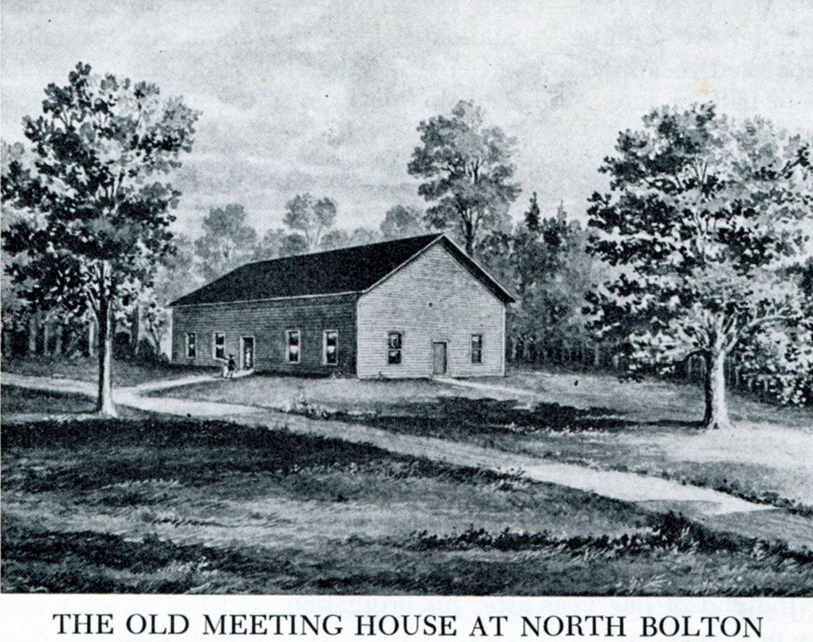
By the early 1820's the old meeting house was no longer adequate for the growing town, and in 1826 a new church was built on the West side of Hartford Turnpike at the corner of Center Road. The original meeting house was moved to Rockville in 1831 or 1832 and made the east wing of the old Frank Mill, later known as the Florence Mill. In 1801 the Hartford and Tolland Turnpike Company was chartered to build and maintain the road from East Hartford to Tolland; a main route from Hartford to Boston. It may have been at this time the road was straightened bypassing Meetinghouse Hill. Vernon received its charter in 1808 allowing us to set our own priorities and we set about improving our roads, building new ones and abandoning others. Thus in 1829, three years after the new church opened, the road east of Tinker's store, leading by the old meeting house was closed. The old path up Meetinghouse Hill was left much as it was in pioneer days. Farming Meetinghouse Hill
The field at Meetinghouse Hill returned to farming. About 1900 Norman Hollister Strong (1857-1911) bought the 33 acres between Route 30 and Cemetery Road. This included the iconic red barn, although he declined to buy the neighboring house, which was part of the farm and available for $500. When Strong bought the field it was run down with yellow birches and brush. The marshy wetlands had turned into a swamp and a ditch was dug to drain it. There was a good spring on the land that provided the pasture and cattle with water. The spring was also used for a number of years to supply water to the Tolland County Temporary Home For Children near Center Road. The iconic Red Barn, which is on the Historic Barns of Connecticut list, was used for hay and equipment storage - especially in the winter. At times the downstairs was open for cattle to get out of the elements. It was damaged by the hurricane of September 1938 with some of the roof boards blowing across the road and hitting Ecker's barn. Many current residents remember Norman Strong bringing his milking cows down from the field each day to his barn on West Road for milking. Meetinghouse Hill Today
When Norman Strong died in 2010 the Meetinghouse Hill field was part of the Strong Family Limited Partnership, LLP. Area farmers rented the field to grow corn, harvest the hay, and graze their cows. When the Partnership decided to sell the property in 2014 a few area residents formed Meetinghouse Hill, LLC to preserve this piece of our Colonial and agricultural history. Area farmers continue to raise corn and hay and a small herd of beef cattle grazed there in 2015. Funds were raised by the LLC through grants and local donations to preserve this field and another on West Road. Now Connecticut Farmland Trust, Inc. holds the development rights and the land was returned to the Strong Family Farm nonprofit in 2019. Trails are being created and the field is open so everyone can walk the historic path up Meetinghouse Hill and enjoy the view. Nowhere else in town can you walk on the same unpaved path used by the Podunks, perhaps Rev. Thomas Hooker and John Talcott, and certainly our Colonial ancestors.
Updated January 2021 |
Home | Activities | News | References | Search | Site Map | Contact Us © Copyright The Tankerhoosen. All rights reserved. |