 |
| Home | Geography | History | Biology | Recreation | News | Resources |
| Timeline | Narrative | Events | Places | People |
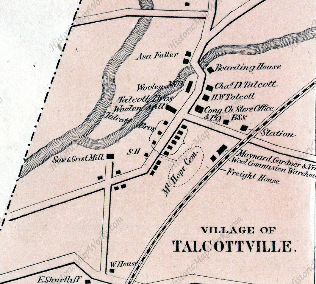
Talcottville Grist MillTalcottville under the Talcott brothers was a company owned and managed town. Typical of other American mill towns of the time, factory owners were paternalistic towards their employees providing them with not only housing, but also a church, school, library, social hall and store. A Talcott owned farm provided dairy products and produce as well. It was the stated purpose of the Talcott's to operate an orderly and well-regulated industrial village. It has also long been known that they had a grist mill in the flats near the conjunction of the Tankerhoosen and Hockanum Rivers, but little has been known about it. When were they built and by whom? How was water brought to the mill and what other structures were at the location and when did the mill stop operating and why? There is little reference to this mill in local histories. In his 2016 book "Water Powered Mill Sites in Vernon, CT" Richard Symonds, Jr describes the site as follows: "Little historical or site information could be found for this mill except it was a mid-1800s mill appearing on the 1869 map of Vernon. The site was on a flat area, with little fall for power except for the flowing water of the Tankerhoosen. No remnants were found but the characteristics of the site would lead one to believe that the only source of power would have been an undershot waterwheel." Now new information is emerging that fleshes out what was actually a mill complex. The following advertisement was stumbled on in an old issue of the Hartford Courant:
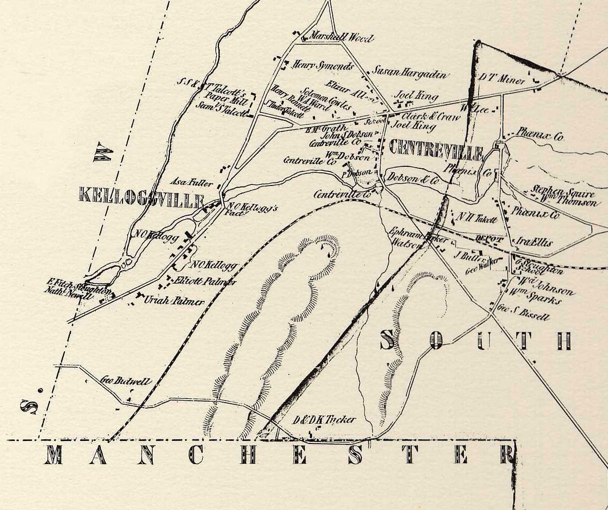
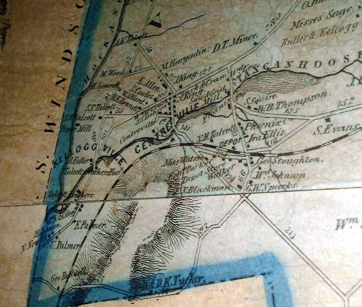
William Dobson, a son of mill owner Peter Dobson, died relatively young at age 48 in 1862, and his widow was selling his share of the Talcottville grist, saw and cider mill complex. Per the advertisement the site also included 14 acres with two houses and a barn. William's widow Marie sold their third interest in the mills to the Talcott Brothers in August of 1865 (Vernon Land Records 13-212) for $1,800. Apparently this was the first time they owned a share of these mills. The Talcott Brothers purchased the mills from Nathaniel Kellogg's heirs in 1856 and were just beginning to expand the operation as the Civil War brought additional business to their mills. The deed adds that the mills were located on the highway leading from Talcott Brothers Mill westward and that the title comes with all the water privileges. It also says William bought his share in 1859 from Henry J. Johnson. William Dobson purchased the property from Henry J. Johnson in 1859 and that deed (8-408) provides additional detail on the site. William seems to be buying the entire site rather than just a third. The site includes the saw and grist mills (no cider mill), 2 houses, a barn and the water privilege. The privilege allows raising the water in the Tankerhoosen from where it runs across Elliott Palmer's land to the line of the Talcott Brothers. It also permits entering Palmer's land to repair the dam, raceway and containments. The parcel runs 600 feet on the turnpike, then crosses the Hockanum River to the west and continues up the west side of the Tankerhoosen. Abutters include Elliot Palmer, Asa Fuller and Henry Johnson. What The Maps ShowFortunately during this period we have several excellent maps from 1853, 1859 and 1869. Click on them for a larger size. The 1853 map, the first detailed map of Vernon,shows the race from the Tankerhoosen to the mill and returning to the Hockanum. A roadway comes off the turnpike road. The mill village is still owned by Nathaniel Kellogg who built most of the houses around 1840. Elliott Palmer lives in the village and his farm likely extended to the Tankerhoosen. Asa Fuller lived in the Warburton House and he likely farmed back to the Hockanum. Thus a dam on the Tankerhoosen would overflow both their farms. The map also shows 2 houses at the entrance owned by Newell and Stoughton. Were they the two houses that were part of the complex? The mill is not identified but may have belonged to E. Fitch. Henry Johnson is not shown but he was a resident of Manchester. The 1869 Manchester map does show a Mrs. Johnson a little further south at the corner of the turnpike and today's Taylor Street. The 1859 map is quite similar to the 1853 map and is less detailed as it is part of a full Tolland County map. By 1869 the Talcott Brothers had expanded the village and owned at least a third of the grist mill. Elm Hill Road and Welles Road connected to Taylor Street. Many of the houses and buildings were constructed in 1860, including the school. Welles Road goes directly across the turnpike to the mill and the two houses on the northwest side of the road are still shown.
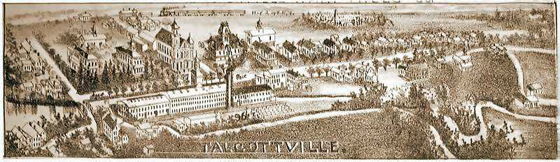
When Mill Use End?The Talcott Brothers bought the grist mills and 13 acres from Marie Dobson in 1865. They appear to be the last owner of the operating grist mill holding until it closed. They likely used it exclusively for their employees and bought grain from area farmers rather than grinding for them and keeping a share. How long did it continue to operate as a grist mill? They are listed as a the 'Talcott Brothers Grist Mill' on and off in the Price & Lee Directories until 1910. This survived the 1869 and many other seasonal floods. It is likely the Hartford Turnpike road bypass of Main Street also took the mill. But when did this happen? The 1890 USGS map does not show the bypass. The 1895 sketch of Talcottville also shows no bypass. But it does seem to show the area of the mills and that it may be the exit race from the big mill that powers the grist mill.
The oldest map I have with the new road is the 1925 Trolley map. It shows Talcottville Road (Rt 83) bypassing Main Street and the trolley line. At this point Vernon Circle does not exist. The map also shows the 2 houses on the NW side of the intersection where the mill once was. The river location looks the same as in the 1869 map. House locations are numbered so must be a list of owners. Looks like the trolley may have been laid on another map. Vernon Circle was built in 1934. So the bypass was probably added 1910-1920. Does Vernon's Engineering Dept. have any old maps? DOT? Check purchases by State during this time period. Talcott to State of CT? | ||
Home | Activities | News | References | Search | Site Map | Contact Us © Copyright The Tankerhoosen. All rights reserved. |